Unveiling the secluded charm of upper sols creek falls
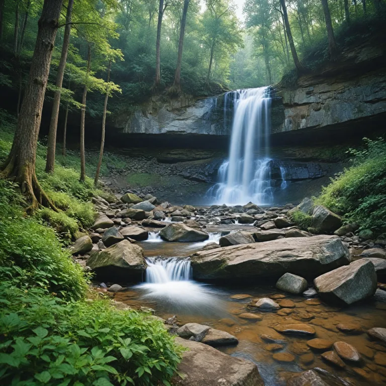
Upper sols creek falls remains one of North Carolina’s most captivating yet lesser-known waterfalls, nestled deep within the Nantahala national forest. This area is renowned for its pristine forest, winding creek, and the dramatic main drop of the falls, which plunges 18 meters into a tranquil pool. The falls are accessible year-round, offering a serene escape for those seeking solitude and natural beauty. The path to the falls is unmarked, requiring visitors to rely on GPS navigation and detailed trail descriptions, which adds to the sense of adventure and exclusivity.
The trail to upper sols creek falls is a challenging 1.3-kilometer hike through dense forest, with steep descents and uneven terrain. Hikers are advised to wear sturdy boots and carry navigation tools, as the area is remote and facilities are nonexistent. Along the way, the creek meanders through lush vegetation, and the sound of cascading water grows louder as you approach the waterfall. The forest surrounding the creek is home to diverse flora and fauna, making the journey as rewarding as the destination.
For those passionate about off-the-beaten-path destinations, upper sols creek falls offers an authentic wilderness experience. The area’s isolation ensures that visitors can enjoy the sights and sounds of nature without the crowds often found at more popular carolina waterfalls. The falls, creek, and surrounding forest create a harmonious landscape that invites exploration and reflection. This hidden gem is a testament to the enduring allure of North Carolina’s natural wonders.
Navigating the unmarked trail: essential tips for a safe hike
Reaching upper sols creek falls requires preparation and respect for the environment. The trail begins near Sols Creek in the Nantahala national forest, with GPS coordinates (35.26348, -83.01920) serving as the most reliable guide. The hike covers approximately 0.8 miles, with a steep descent to the creek and several side paths that can lead to confusion. It is crucial to stay alert and use navigation tools, as the trail is not maintained or signposted.
Hikers should be aware that the area is characterized by slippery rocks, dense undergrowth, and occasional crossings of side creeks. Trekking poles can provide stability, especially during wet conditions when the path becomes treacherous. The left side of the creek offers the most direct access to the falls, but caution is necessary to avoid private property boundaries. The forest canopy provides shade, but it also limits visibility, so planning your hike during daylight hours is recommended.
Safety is paramount in this remote area. Carry sufficient water, snacks, and a first aid kit, as there are no facilities or emergency services nearby. Inform someone of your plans before setting out, and consider hiking with a partner or local group. For more guidance on responsible hiking in North Carolina’s national forests, consult the official Nantahala National Forest visitor information. By preparing adequately, you can fully appreciate the beauty and tranquility of upper sols creek falls while minimizing risks.
The ecological significance of the upper sols creek falls area
The upper sols creek falls area is a vital component of the Nantahala national forest ecosystem. The creek, river, and surrounding forest support a rich diversity of plant and animal life, including several species unique to the southern Appalachian region. The falls themselves create a microhabitat where moisture-loving plants thrive, and the constant flow of water sustains the health of the creek downstream.
Preservation of this area is a priority for the managing authority, Nantahala National Forest, which oversees conservation efforts and promotes responsible recreation. The forest is home to a network of interconnected waterways, including bear creek, wolf creek, flat creek, and falls creek, each contributing to the region’s ecological balance. The presence of multiple waterfalls, such as paradise falls and side sols, enhances the area’s appeal for nature enthusiasts and photographers alike.
Visitors are encouraged to adhere to Leave No Trace principles, ensuring that the forest, creek, and falls remain unspoiled for future generations. Increased awareness and visitation can lead to greater conservation efforts and community engagement, fostering a deeper appreciation for North Carolina’s natural heritage. For those interested in exploring other hidden waterfalls and trails, this guide to off-the-beaten-path destinations provides valuable insights and recommendations.
Photographic opportunities and the art of waterfall exploration
Upper sols creek falls offers exceptional opportunities for photography, with its dramatic main drop, lush forest backdrop, and the interplay of light and water. The area’s remoteness ensures that photographers can capture the falls and creek without interference, allowing for creative compositions and long exposure shots. The best vantage points are found along the left side of the creek, where the view of the waterfall is unobstructed by vegetation.
The surrounding forest, river, and side creeks provide a wealth of subjects for nature photographers. Early morning and late afternoon light create dynamic contrasts, highlighting the textures of moss-covered rocks and the movement of water. The area’s diverse plant life, including ferns and wildflowers, adds depth and color to landscape images. Photographers should be mindful of slippery surfaces and changing weather conditions, which can affect both safety and the quality of their shots.
For those seeking to expand their portfolio of carolina waterfalls, upper sols creek falls stands out as a unique and rewarding subject. The combination of challenging access, pristine environment, and striking natural features makes it a favorite among experienced photographers. To further enhance your waterfall photography skills, consider exploring resources on composition, lighting, and post-processing techniques.
Respecting private property and local guidelines
Access to upper sols creek falls involves traversing a mix of public and private lands. It is essential to respect property boundaries and adhere to local regulations to maintain positive relationships with landowners and preserve access for future visitors. The trailhead is located near a private property boundary, so parking and entry should be done discreetly and without causing disruption.
Visitors should stay on established paths and avoid creating new trails, which can lead to erosion and habitat disturbance. The left side of the creek provides the safest and most direct route to the falls, but hikers must be vigilant to avoid encroaching on private land. Signage in the area may be limited, so using GPS coordinates and detailed maps is recommended to navigate accurately.
Local hiking groups and the Nantahala National Forest authorities offer guidance on responsible exploration of the area. By following their recommendations and practicing good stewardship, visitors can help ensure that upper sols creek falls remains accessible and pristine. As one expert notes, "From Lake Toxaway, drive north on NC-281 for 16.7 miles, turn right on Charleys Creek Road, drive 0.4 miles, and park on the right before a left-hand turn. The trail is unmarked; use GPS coordinates 35.26348, -83.01920 to navigate." This advice underscores the importance of preparation and respect for the land.
Seasonal highlights and planning your visit to upper sols creek falls
Upper sols creek falls can be visited throughout the year, with each season offering distinct experiences. In spring, the forest comes alive with vibrant foliage and blooming wildflowers, while the creek and waterfalls flow at their fullest. Summer provides warm temperatures and lush greenery, making it ideal for extended hikes and photography sessions. Autumn transforms the area into a tapestry of red, orange, and gold, creating a stunning backdrop for the falls and creek.
Winter visits are possible, but hikers should be prepared for colder temperatures and potentially icy conditions on the trail. The area’s remoteness means that weather can change rapidly, so checking forecasts and trail conditions before setting out is essential. The falls, creek, and surrounding forest are particularly enchanting after rainfall, when the water volume increases and the landscape glistens with moisture.
When planning your trip, consider the length and difficulty of the hike, as well as the lack of nearby facilities. Carry all necessary supplies, including water, snacks, and navigation tools, and allow ample time to complete the hike during daylight hours. For those seeking additional adventure, the national forest offers numerous other trails, lakes, and waterfalls to explore, each with its own unique charm and challenges.
Key statistics about upper sols creek falls and the surrounding area
- Waterfall height: 18 meters (60 feet)
- Trail length: 1.3 kilometers (0.8 miles)
- Accessible year-round, with varying conditions depending on the season
- No facilities nearby; visitors must come prepared
- Located within Nantahala National Forest, Cullowhee, North Carolina
Frequently asked questions about upper sols creek falls
How do I get to Upper Sols Creek Falls?
From Lake Toxaway, drive north on NC-281 for 26.9 kilometers, turn right on Charleys Creek Road, drive 0.6 kilometers, and park on the right before a left-hand turn. The trail is unmarked; use GPS coordinates 35.26348, -83.01920 to navigate.
Is the hike to Upper Sols Creek Falls suitable for beginners?
The hike is challenging due to steep and unmarked trails, making it more suitable for experienced hikers.
Are there any facilities near Upper Sols Creek Falls?
No, there are no facilities nearby. Visitors should come prepared with necessary supplies.
Trustful sources:
