Shaping a west coast driving tour beyond the usual map
A refined west coast driving tour begins with clarity of intent. Many travelers rush the road and miss the quieter stretches of the Pacific coast where time slows and the landscapes feel almost private. To focus on off the beaten path trip destinations, you must first decide how many days you can genuinely spare.
Late spring to early fall offers the most favorable weather conditions, so align your road trip window with calmer skies and longer light. This allows you to divide the west coast into thoughtful segments, from the wild west deserts near Death Valley to the misty forests north of San Francisco. Depending on stops and pace, it can range from one to three weeks, which gives you space to explore both iconic and lesser known coast road sections.
Use GPS navigation and online maps, but treat them as tools rather than strict rulers of your route. Allocate sufficient time for each day so that a 200 to 250 miles stretch never feels like a forced march, especially when a narrow pacific coast highway section demands slower speeds. Plan accommodations in advance in high demand areas such as Big Sur and the smaller towns near Half Moon Bay, yet leave one or two nights flexible for spontaneous detours inland. Some bridges and specific areas may have tolls ; it's advisable to check in advance and factor this into your vehicle budget.
Quiet Pacific edges from San Diego to hidden coves near Big Sur
Starting your west coast driving tour in San Diego lets you ease into the rhythm of the road. The city’s relaxed neighborhoods sit close to less crowded beaches where early morning walks frame your first pacific coast views. As you move north, keep your vehicle range modest on the first day to adjust to local traffic and coastal weather.
Between San Diego and Santa Monica, pause in smaller coastal communities that sit west of the main freeway, where the coast road feels more intimate. Increased interest in road trips due to flexibility and safety has encouraged local authorities to improve viewpoints and parking, which benefits travelers seeking quieter landscapes. Use travel guides and curated blogs about remote travel destinations to identify beaches and headlands that rarely appear in mainstream itineraries.
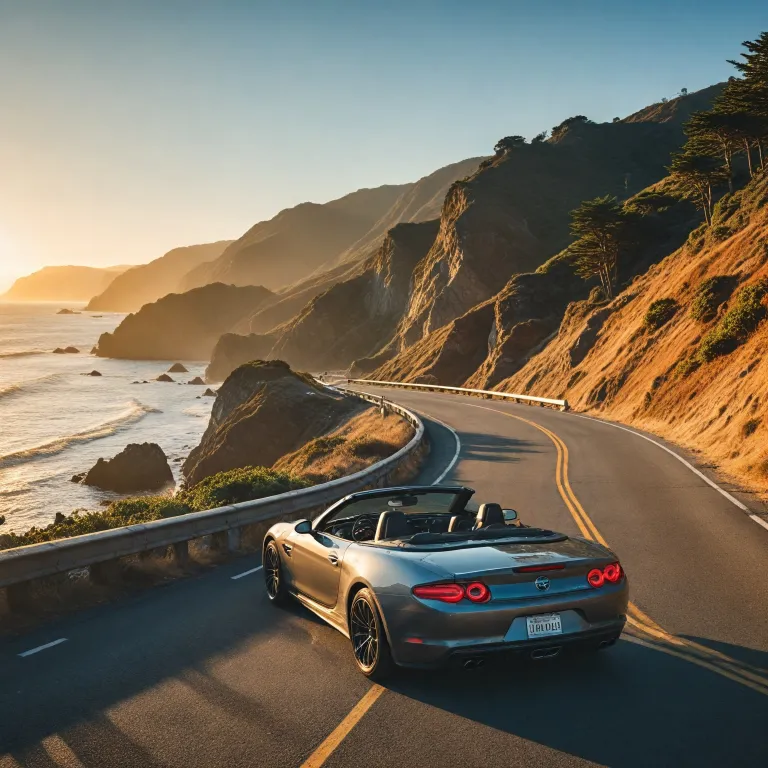
North of Santa Monica, the pacific coast highway begins to reveal more rugged stretches, with low cliffs and narrow pullouts that reward patient drivers. Allocate at least two days between Santa Monica and Big Sur so you can explore side roads leading to small coves and state parks west of the main artery. Growing popularity of eco friendly travel options along the West Coast has also brought more responsible tour operators who limit group sizes and emphasize low impact visits to national parks and marine reserves.
Big Sur, Half Moon Bay and the art of slow coastal travel
The section between Santa Barbara and Big Sur is where a west coast driving tour becomes truly immersive. Here, the pacific coast highway clings to cliffs, and every few miles a new viewpoint opens onto dramatic landscapes that feel far removed from city life. Travelers should keep daily distances short, perhaps 150 to 200 miles, to allow time for walks and photography.
Plan at least two days in and around Big Sur itself, using early mornings and late afternoons to explore quieter trails and beaches. Increased digital resources for trip planning and navigation make it easier to track road conditions, which is essential on this coast road where landslides occasionally close segments. When closures occur, a flexible road trip mindset lets you reroute inland through redwood valleys and agricultural towns that reveal another side of california.
North of Big Sur, Half Moon Bay and the nearby Half Moon Bay State Beach offer a gentler pacific coast experience. This is an ideal place to pause your trip for a restorative day, perhaps combining coastal walks with a refined stay similar in spirit to the serene retreats described in this guide to remote islands with no crowds. From here, san francisco lies only a short drive north, yet the atmosphere remains markedly calmer than in the city itself. Use this transition to review your remaining days, your vehicle needs, and any national park permits required further inland.
San Francisco, Half Moon Bay and the quiet side of northern california
Arriving in san francisco during a west coast driving tour can feel like stepping briefly off the road into a cultural crossroads. To maintain the off the beaten path spirit, base yourself in neighborhoods west of downtown, where residential streets lead quickly to ocean facing parks. From here, you can reach the pacific coast in minutes while still enjoying refined dining and arts.
Dedicate at least one full day to san francisco, then another to the surrounding coast road and nearby national parks. The length of California State Route 1 extends for about 1 055 kilometres, and this northern section includes lesser known beaches and headlands that many road trips bypass. Consider a loop that links Half Moon Bay, small inland wineries, and forested parks north of the Golden Gate, keeping your daily miles modest to preserve time for walks.
As your trip continues north, U.S. Route 101 becomes the main spine of the west coast, threading through redwood landscapes and quiet river valleys. The length of U.S. Route 101 reaches roughly 2 414 kilometres, with many segments running close to the pacific coast yet remaining uncrowded outside peak holiday periods. For travelers who appreciate refined stays, curated resources such as this refined guide to hotels can inspire similar standards when selecting coastal lodgings that match the elegance of the journey.
Detours to national parks, deserts and the quiet wild west
One of the strengths of a west coast driving tour lies in its proximity to varied national parks and desert landscapes. From the california coast, a well planned detour can lead you east to Death Valley, where the wild west atmosphere contrasts sharply with the pacific breeze. Such a side trip requires careful attention to vehicle readiness, water supplies and fuel range.
Farther north, travelers often combine the coast road with inland routes to reach major national parks and lesser known reserves. The number of state parks along the Oregon Coast Highway reaches seventy seven, offering countless options for short walks, picnic stops and quiet viewpoints. By alternating days on the pacific coast with days in forested valleys, you create a rhythm that keeps the trip fresh and avoids fatigue.
Ambitious itineraries may extend even farther inland toward Bryce Canyon and other american icons, though this shifts the focus from pure coast highway travel. When time is limited, prioritize one or two national park detours rather than many rushed visits, ensuring each day retains a sense of calm exploration. Tour operators and local tourism boards can assist with permits and seasonal advice, while mobile apps provide real time updates on road closures, weather and trail conditions.
Practical planning for miles, days and off the beaten path comfort
Transforming a west coast driving tour into a refined yet adventurous experience requires disciplined planning. Begin by mapping your total miles and dividing them into realistic days, allowing for slower segments on the pacific coast and in mountainous national parks. Many travelers find that 150 to 250 miles per day balances progress with meaningful exploration.
Choose a vehicle that suits both coast road curves and longer inland stretches, paying attention to luggage space and fuel efficiency. Personal cars, rental vehicles and guided tour buses each offer different levels of flexibility, so align your choice with how independently you wish to travel. Innovation in mobile navigation now allows real time updates, but always carry a physical map as backup in remote areas where coverage fades.
Plan overnight stops in places like Santa Barbara, palm springs, Santa Monica and smaller towns near Half Moon Bay to break the trip into elegant stages. In Oregon and Washington, consider quieter coastal villages west of the main highway, where local american hospitality feels more personal and the pacific coast remains largely uncrowded. Finally, remember that a thoughtful west coast itinerary values rest as much as movement, so schedule occasional empty days where the only agenda is to walk, read and watch the changing light over the ocean.
Key statistics for a refined west coast driving tour
- Length of U.S. Route 101 : approximately 2 414 kilometres from california through Oregon to Washington.
- Length of California State Route 1 : roughly 1 055 kilometres of scenic pacific coast driving.
- Number of state parks along the Oregon Coast Highway : seventy seven protected areas accessible from the main road.
Essential questions for planning your west coast driving tour
What is the best time of year to do a west coast driving tour ?
Late spring to early fall offers the most favorable weather conditions. During this period, coastal fog is more predictable, mountain passes are generally open, and daylight hours are long enough to combine driving with walks and cultural visits. Shoulder seasons within this window also provide fewer crowds on the pacific coast and in popular national parks.
Are there any toll roads on this route ?
Some bridges and specific areas may have tolls ; it's advisable to check in advance. Most of the primary coast highway and U.S. Route 101 segments remain toll free, but urban crossings near major cities can require electronic payment. Rental car companies and local tourism boards can clarify current toll systems so that your vehicle is correctly registered before the trip begins.
How long does a typical west coast driving tour take ?
Depending on stops and pace, it can range from one to three weeks. A shorter itinerary focuses on a single region such as southern california and Big Sur, while a longer journey links san diego, san francisco, Oregon and Washington. The ideal duration balances your available time, preferred daily miles and the number of national parks and coastal towns you wish to include.
